Severe Weather Awareness Week April 12-16
Description: SECO Weather Storm Spotters Report to the National Weather Service of Pueblo. Only NWS trained spotters report weather on the SECO News network and on SECO Weather. This guide helps you understand the terminology and be better prepared.

Severe Weather Awareness Week - Understanding Watches and Warnings:
The Storm Prediction Center in Norman Oklahoma forecasts the risk for severe weather across the country several days in advance. These outlooks help to inform you if there is a risk for severe weather. If severe weather becomes likely, a watch can be issued, alerting you to the increased risk for severe weather. If severe weather is possible in your area, you should have a plan on where to go for shelter and be ready to act if severe weather were to occur.
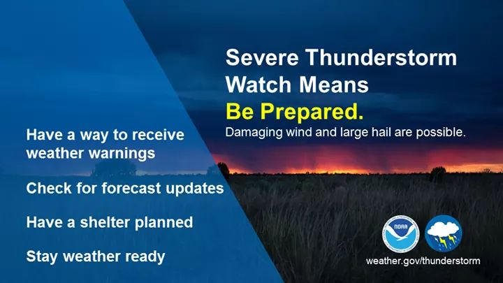 Severe Thunderstorm Watch Means Be Prepared. Damaging wind and large hail are possible.
-Have a way to receive weather warnings-Check for forecast updates-Have a shelter planned-Stay weather ready
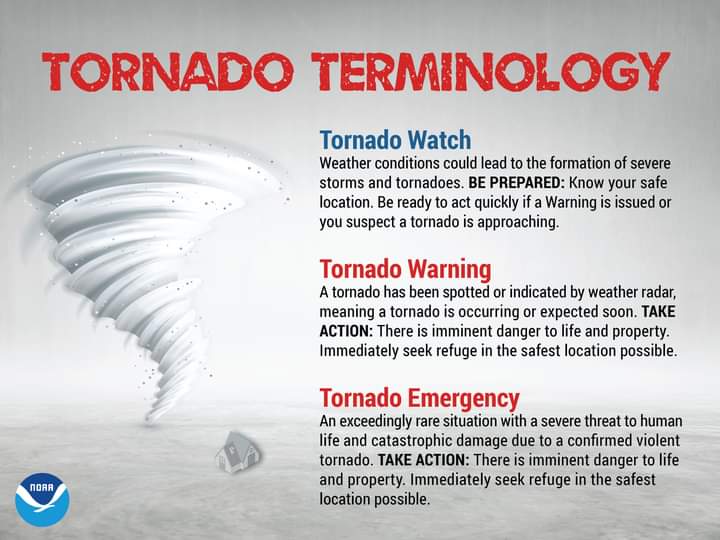 Tornado Terminology:
Tornado Watch: Weather conditions could lead to the formation of severe storms and tornadoes. BE PREPARED: Know your safe location. Be ready to act quickly if a Warning is issued or you suspect a tornado is approaching.
Tornado Warning: A tornado has been spotted or indicated by weather radar, meaning a tornado is occurring or expected soon. TAKE ACTION: There is imminent danger to life and property. Immediately seek refuge in the safest location possible.
Tornado Emergency: An exceedingly rare situation with a severe threat to human life and catastrophic damage due to a confirmed violent tornado. TAKE ACTION: There is imminent danger to life and property. Immediately seek refuge in the safest location possible.
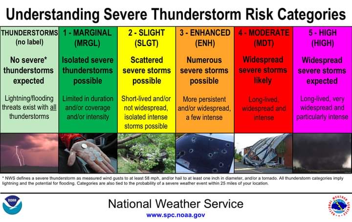 Understanding Severe Thunderstorm Risk Categories
1 - Marginal (MRGL) Isolated severe thunderstorms possible - Limited in duration and/or coverage and/or intensity
2 - Slight (SLGT) Scattered severe storms possible - Short-lived and/or not widespread, isolated intense storms possible
3 - Enhanced (ENH) Numerous severe storms possible - More persistent and/or widespread, a few intense
4 - Moderate (MDT) Widespread severe storms likely - Long-lived widespread and intense
5 - High (HIGH) Widespread severe storms expected - Long-lived, very widespread and particularly intense
Help Keep Your Community Weather Ready by Sharing Severe Weather Watch and Warning Information from SECO Weather on the SECO News Network.
Follow SECO News on Facebook.
Subscribe to the SECO News YouTube Channel.
SECO Weather Sponsor


.png)


.png)
.png)


.png)


