NWS: Snow Accumulation + High Winds Weds+Thurs
Description: This Hazardous Weather Outlook has been issued by the National Weather Service Office of Pueblo.

Hazardous Weather Outlook
Hazardous Weather Outlook National Weather Service Pueblo CO 505 AM MST Wed Jan 5 2022 COZ058>089-093>099-061215- Western Mosquito Range/East Lake County Above 11000 Feet- Leadville Vicinity/Lake County Below 11000 Feet- Eastern Sawatch Mountains Above 11000 Feet- Western Chaffee County Between 9000 and 11000 Feet- Central Chaffee County Below 9000 Feet- Western Mosquito Range/East Chaffee County Above 9000 Feet- Saguache County West of Continental Divide Below 10000 Feet- Saguache County East of Continental Divide Below 10000 Feet- La Garita Mountains Above 10000 Feet- Upper Rio Grande Valley/Eastern San Juan Mountains Below 10000 Feet-Eastern San Juan Mountains Above 10000 Feet- Del Norte Vicinity/Northern San Luis Valley Below 8500 Feet- Alamosa Vicinity/Central San Luis Valley Below 8500 Feet- Southern San Luis Valley- Northern Sangre de Cristo Mountains Between 8500 And 11000 Feet- Northern Sangre de Cristo Mountains Above 11000 Feet- Southern Sangre de Cristo Mountains Between 7500 and 11000 Feet- Southern Sangre de Cristo Mountains Above 11000 Feet- Northwestern Fremont County Above 8500 Feet- Western/Central Fremont County Below 8500 Feet- Wet Mountain Valley Below 8500 Feet- Wet Mountains between 6300 and 10000 Feet- Wet Mountains Above 10000 Feet- Teller County/Rampart Range Above 7500 Feet/Pikes Peak Between 7500 And 11000 Feet-Pikes Peak Above 11000 Feet- Canon City Vicinity/Eastern Fremont County- Northern El Paso County/Monument Ridge/Rampart Range Below 7500 Feet- Colorado Springs Vicinity/Southern El Paso County/Rampart Range Below 7400 Feet-Pueblo Vicinity/Pueblo County Below 6300 Feet- Walsenburg Vicinity/Upper Huerfano River Basin Below 7500 Feet- Trinidad Vicinity/Western Las Animas County Below 7500 Feet- Crowley County-La Junta Vicinity/Otero County- Eastern Las Animas County-Western Kiowa County- Eastern Kiowa County-Las Animas Vicinity/Bent County- Lamar Vicinity/Prowers County-Springfield Vicinity/Baca County-
505 AM MST Wed Jan 5 2022
This hazardous weather outlook is for portions of central...east central...south central and southeast Colorado. .
DAY ONE...Today and Tonight Snow will develop over the central mountains today, continuing through tonight.
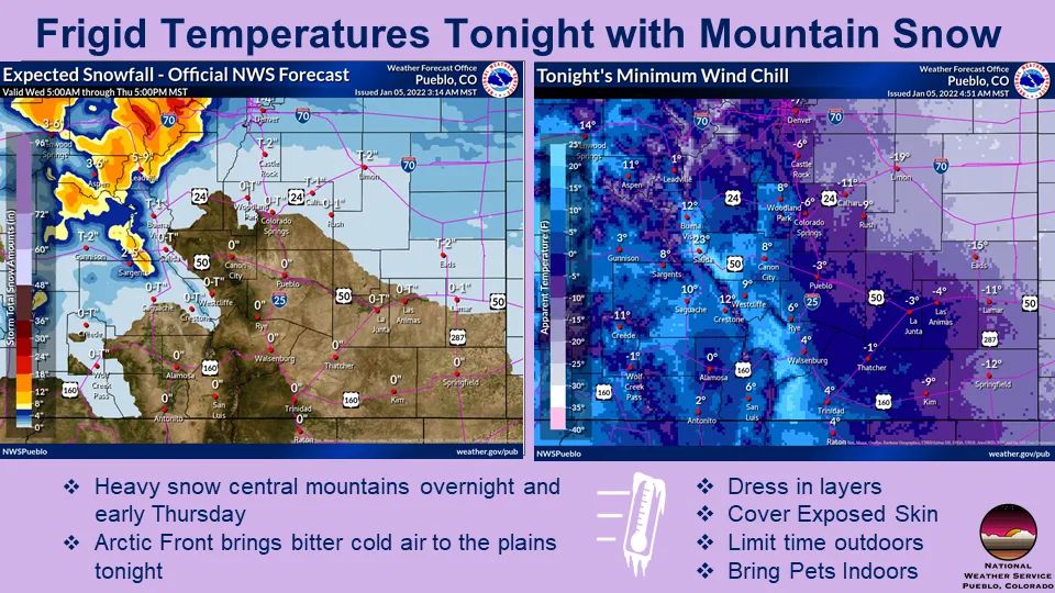
Accumulations of 6 to 12 inches are expected by early Thursday morning over the higher peaks of the Sawatch and Mosquito Ranges, while 4 to 8 inches is possible over lower portions of Lake County around Leadville.
Strong winds will create areas of blowing and drifting snow and lower visibility over Fremont, Tennessee and Monarch Passes both today and tonight. Over and near the mountains today, strong west winds are likely, with gusts of 60 to 70 mph over the higher peaks, and 50 to 60 mph across lower east facing slopes and the adjacent plains. Tonight, an arctic cold front will bring strong north winds and very cold air to much of the plains, with winds chills of 15 to 20 below zero over the eastern plains near the Kansas border after midnight. .
DAYS TWO THROUGH SEVEN...Thursday through Tuesday Light snow will be possible Thursday through mid day over the Central Mountains, mainly north of Cottonwood Pass. An inch or two of accumulation is possible. Another round of snow will be possible along the Continental Divide Saturday into Sunday. A few inches of accumulation are possible. Light rain and snow will be possible Saturday night into Sunday morning for the Eastern Mountains, out into the Interstate 25 corridor. Precipitation type will be highly dependent on temperatures. .
SPOTTER INFORMATION STATEMENT...
Weather conditions that meet reporting criteria for spotters will be possible today and tonight over the central mountains.
Follow SECO Weather on Facebook.
Follow SECO News on Facebook.
Subscribe to the SECO News YouTube Channel.
SECO Weather Sponsor
.png)


.png)


.png)


.png)


.png)


