Gold Mountain Fire Holds at 39,691 Acres, 87% Contained as Crews Target Cimarron Ridge Hot Spots
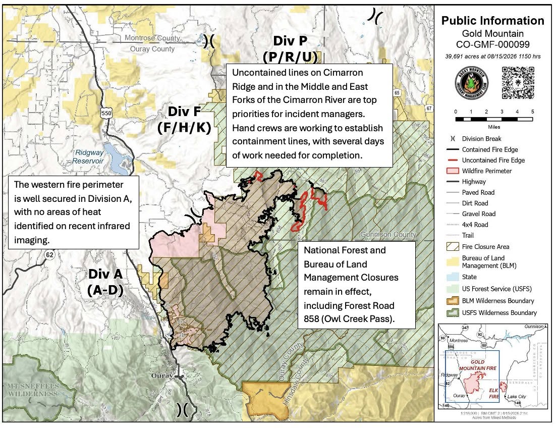
Description: The Gold Mountain Fire near Ouray, Colorado, remains 39,691 acres and 87% contained as firefighters tackle hot spots on Cimarron Ridge and build additional fireline to prevent northern spread...
Published: 08/17/2026
Byline: SECO News

Fire Update – Gold Mountain Fire
Monday, August 17, 2026 – 8:00 a.m.
Rocky Mountain Complex Incident Management Team 2
Rodney Redinger, Incident Commander
Information Phone: 970-355-3286
Email: 2026.goldmountain@firenet.gov
Information Staffing Hours: 8 a.m. to 8 p.m.
Size: 39,691 acres | Containment: 87% | Cause: Undetermined | Start Date: June 27, 2026 @ 5:33 p.m. | Location: Approx. 2 miles NE of Ouray, CO | Total Personnel: 115
Safety Message: Fire area closures remain in effect for public safety. While the immediate threat of the fire may have passed, hazards it created can persist for weeks or even months. Fire-weakened trees may look green and healthy but can fall unexpectedly across roads, trails, and campsites. Burned trees and stumps can also create hidden ash pits that remain extremely hot beneath the surface long after the fire has passed. Roads and trails may be damaged or weakened by water and wind erosion, and additional foot or motorized traffic can worsen erosion and cause further damage to the landscape. These hazards are not always visible, making it difficult to determine whether an area is safe simply by looking at it.
Current Situation: Firefighters are working in Division F along the Nate Creek drainage, where the fire is burning in an aspen stand. Crews are extinguishing hot spots and securing the area. Smoke may continue to be visible from this location as warmer and drier weather returns. A Wildland Fire Suppression Module continues to work in the East and Middle Fork drainages. Crews are mopping up hot spots and extinguishing burning logs and surrounding vegetation to reduce the potential for fire to spread. A second crew will join these efforts and construct indirect fireline between the West Fork and the East Fork containment line. This work will create an additional fire break to help prevent the fire from spreading north.
Fire continues to burn on top of Cimarron Ridge. This ridge poses a unique challenge for firefighters due to the high altitude, rugged terrain, and frequent storms passing over the area. Today, firefighters were able to access the ridge, and they will determine if operations can be safely carried out.
Weather and Fire Behavior: High pressure continues to build across the region. This will bring drier conditions with lower humidity and less surface precipitation. Isolated storms may move across the area today, creating the chance of outflow winds that could affect fire behavior.
Closure Orders: Closure orders are still in effect throughout areas of the Gold Mountain Fire, including Owl Pass Road. For current closure information, please visit: https://www.fs.usda.gov/.../gold-mountain-wildfire-area....
No Fly Zone: A Temporary Flight Restriction (TFR) over the Gold Mountain and Elk Fire areas is in effect. Flying drones near the fire is prohibited and can interfere with firefighting aircraft, potentially grounding aerial suppression operations. For more information on safe drone operations, visit knowbeforeyoufly.org. For information on the TFR, visit https://tfr.faa.gov.
For More Information:
Information Phone: 970-355-3286
Email: 2026.goldmountain@firenet.gov
Linktree: https://linktr.ee/2026.goldmountain`
Follow SECO News on Facebook.
Subscribe to the SECO News YouTube Channel.
Click to Zoom
Press releases Sponsor





.jpg)


.png)

.png)










.png)