Colorado Parks and Wildlife Releases March 2024 Gray Wolf Activity Map
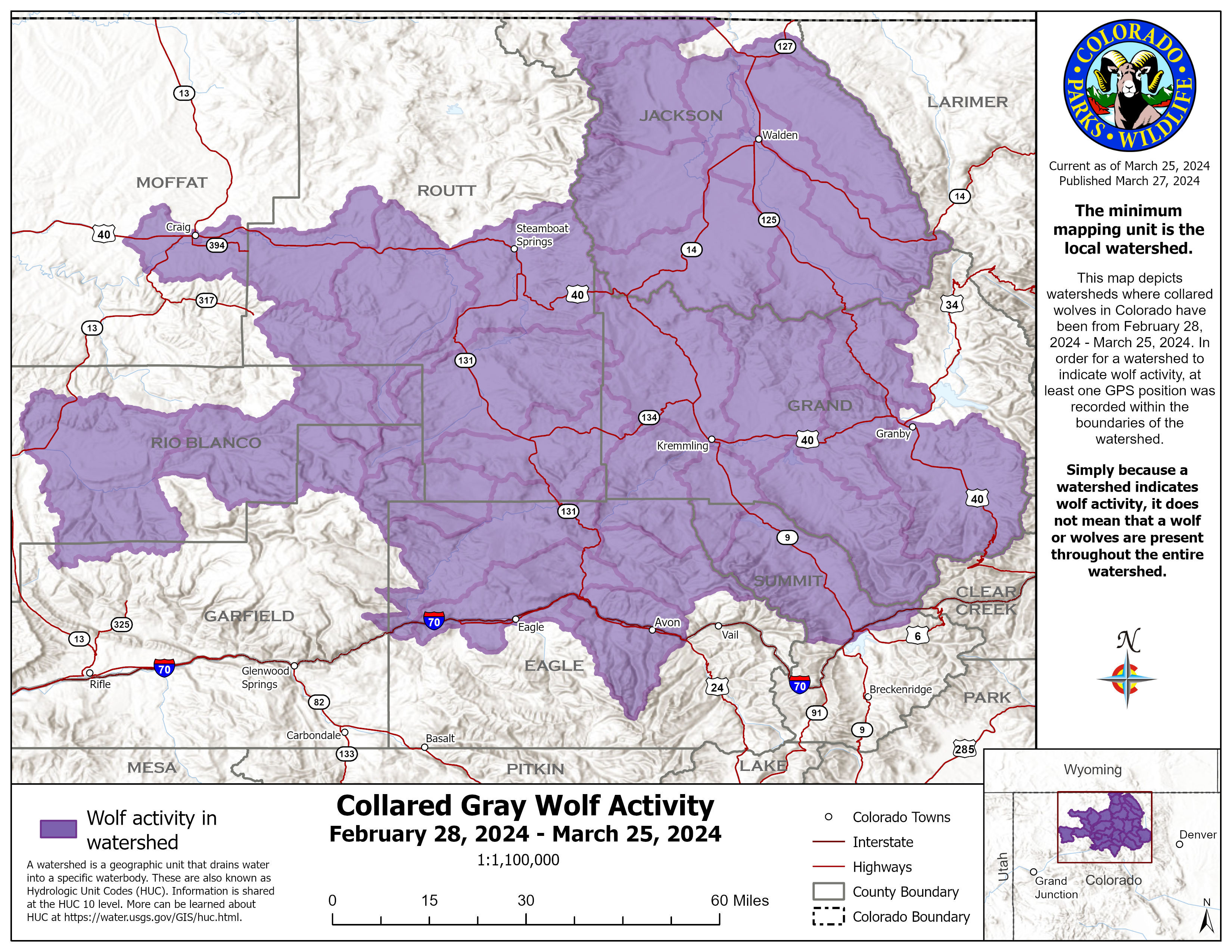
Description: Collared gray wolf activity recorded by Colorado Parks and Wildlife from Feb. 28 to March 25, 2024. A larger map is linked below and available at cpw.state.co.us. Most Recent Colorado Outdoors Colorado Wolf Reintroduction Podcast Below...

Colorado Parks and Wildlife Releases Updated Collared Gray Wolf Activity Map on General Areas Inhabited by Gray Wolves in Colorado
DENVER — An updated map was published today on Colorado Parks and Wildlife’s website to continue informing the public, recreationists, and livestock producers on where collared wolves have been in the past month. CPW will update this map with new information monthly to reflect data for the past 30 days or so, produced on the fourth Wednesday of every month.
Colorado Parks and Wildlife - Collared Gray Wolf Activity Map - March 2024
Notable Updates
- This map was created using GPS data from all functioning collars in Colorado.
- One of the collars placed on a wolf translocated from Oregon is no longer providing signals to CPW biologists. The animal with the failed collar is traveling with another animal with a functional collar, which currently allows CPW to monitor that animal. CPW has confirmed that the animal with the malfunctioning collar is still alive based on visual confirmation from an airplane.
- A collar on another wolf has been identified as partially functional and may not be fully functional in the near future.
- There have been no wolf mortalities in Colorado and no reported livestock depredation in the last 30 days.
About the GPS collar data
- Currently, the collars are programmed to record a position every four hours.
- Once four locations are recorded, the packet of four locations is then transmitted via satellite to CPW biologists.
- Some factors, such as dense cloud cover and closed terrain, can delay the frequency of position recording and data transmission.
- By looking at the data, CPW staff can learn where wolves have been, but they cannot tell where wolves are at a current point in time, nor can they predict where the wolves will go.
- To protect the wolves, specific GPS data will not be shared.
This map depicts watersheds where collared wolves in Colorado have been for the last 30 days. A watershed is a geographic unit that drains water into a specific water body. These are also known as Hydrologic Unit Codes (HUC). Information is shared at the HUC 10 level. Watersheds are the appropriate mapping unit to display wolf activity information because wolves are far more likely to use geographic features to affect their distribution than they are political boundaries. The HUC 10 scale provides detailed information that can help agricultural producers be informed of the general areas where wolf activity is known to exist without being too general (i.e., as a county-level map would be) and also is not so specific to risk the protection of individual wolves (as a finer scale HUC12 map would be). Learn more about HUCs at https://water.usgs.gov/GIS/huc.html.
For a watershed to indicate wolf activity, at least one GPS point from the wolf collars was recorded within the watershed's boundaries. Because a watershed indicates wolf activity, it does not mean that a wolf or wolves are present throughout the entire watershed or that they are currently in it.
CPW reserves the right to buffer maps that will be shared with the public if doing so protects wolf welfare during sensitive times of the year (e.g., breeding, denning, or other sensitive times).
Through immigration from other states, potential collar failure or loss, and the natural reproduction of pups, the proportion of wolves with collars transmitting data will be reduced over time. Therefore, the accuracy of this map will diminish over time as the activity of uncollared wolves may not be included in it. The long-term intention is to maintain at least two collars in each pack.
To learn more about wolves in Colorado, visit the CPW Wolves in Colorado website to find a variety of educational materials. Online resources include:
- Living With Wolves brochure
- Producers Guide to Livestock Depredations; Una guía para el productor sobre la depredación del ganado (En Español)
- Coyote or Gray Wolf: How to Spot the Differences flyer
- Wolf Resource Guide: Hands-on Resource to Reduce Depredations
- Keeping your pets safe where wolves are present
Listen to the new episode of the Colorado Outdoors Podcast, “The Colorado Gray Wolf Reintroduction.” In our latest episode, we hear from our Colorado Parks and Wildlife team members actively engaged in reintroducing gray wolves in Colorado. Tune in as they share their experiences, recounting their work in Oregon, where wolves were captured for relocation to Colorado, and from the release sites in Colorado.
Follow SECO News on Facebook.
Subscribe to the SECO News YouTube Channel.
Files
Colorado Gray Wolf GPS Collar Map - February 2024
Colorado Gray Wolf GPS Collar Map - January
Press releases Sponsor


.png)

.png)


 (728 x 90 px).png)
.png)


.png)

.png)

.png)